Leveraging ArcGIS Online:
From Data to Dynamic Web Maps
with Krieshen Ramkhelawan (GISsat) & Sheetal Sujan, at Esri’s partner Lybra
”GIS is waking up the world to the power of geography, this science of integration, and has the framework for creating a better future.”
– Jack Dangermond

Join us for a comprehensive three-day workshop on leveraging ArcGIS Online to transform your geospatial data into dynamic web maps. In this course, you will learn how to harness the power of ArcGIS Online, a cloud-based platform, to create, customize, and share interactive web maps that effectively communicate spatial information.
Leveraging ArcGIS Online:
From Data to Dynamic Web Maps

Day 1 will introduce you to ArcGIS Online, providing an overview of its capabilities and guiding you through the process of setting up your account and environment. You will learn how to upload and manage various data formats compatible with ArcGIS Online, ensuring data integrity and quality for web mapping.
Day 2, on this day you will delve into the art of building and customizing web maps. Through hands-on exercises, you will master the process of creating visually compelling maps by selecting basemaps, styling layers, configuring pop-ups and labels, and utilizing symbology. Advanced web mapping techniques will be explored, including spatial querying, geoprocessing, and the creation of interactive map presentations and story maps. Sharing and collaboration are vital components of ArcGIS Online, and you will discover how to share your web maps with specific groups or the public, control access and permissions, and embed web maps in websites and applications. Additionally, you will learn how to enhance your web maps by creating and customizing applications and templates.
Day 3 of the course will focus on advanced geospatial analytics and how to create and embed interactive apps and maps. Participants will also learn how to plan, execute and process drone flights for generating orthomosaics, elevation models and 3D models. The course will use ArcGis SiteScan as a tool for drone data management and integration with ArcGis Online. The course will include practical examples and exercises to reinforce the concepts.
Whether you are a GIS professional, analyst, or enthusiast, this course will equip you with the tools to unlock the true potential of your spatial data.
Course Outcomes
ARCGIS ONLINE KNOWLEDGE
Learn how to create web maps using ArcGIS Online
VARIOUS ARCGIS INTEGRATIONS
Explore various data sources and formats that can be integrated into web maps
COMMUNICATE SPATIAL INFORMATION EFFECTIVELY
Share your web maps with others through web apps, story maps, and dashboards
VARIOUS TECHNIQUES
Apply different cartographic techniques and symbology to enhance your web maps
ENHANCED CREATIVITY
Analyze and visualize your spatial data using smart mapping and spatial analysis tools
Who Is This Program For?
This course is:
Designed For Individuals Who Are Interested In Leveraging The Power Of ArcGIS Online To Create Dynamic Web Maps. It Is Suitable For:
Involving employees in optimizing processes increases ownership of work. Our Lean certified professionals involve all relevant process actors to guide and facilitate optimizing processes.
The optimized processes supported with our tailor-made information systems ensure information flow is optimal, human errors are significantly reduced, internal and external client satisfaction is increased.

Course Requirements

No Prior Experience
No prior experience with ArcGIS Online is necessary, as this workshop is designed for beginners and those looking to enhance their web mapping skills.

Bring a Laptop
Participants are required to bring their own laptops with an up to date browser.

Basic GIS Knowledge
Participants should have a basic understanding of GIS concepts and familiarity with working with spatial data.
Course Modules
Day 1

Part 1: Introduction to ArcGIS and its online platform
Duration: 1 hour
- Overview of ArcGIS Online and its capabilities
- Understanding the benefits of cloud-based GIS
- Creating an ArcGIS Online account and setting up the environment

Part 2: Uploading and Managing Data
Duration: 2 hours
- Introduction to different data formats.
- Uploading data.
- Organizing and managing data.
- Data preparation and best practices for web mapping

Part 3: Building and Customizing Web Maps
Duration: 2 hours
- Creating a new web map in ArcGIS Online
- Exploring different basemap options
- Adding and styling layers on the map
- Configuring pop-ups and labels
- Utilizing symbology and visualizations for effective communication
- Creating field data collection apps with ArcGIS Survey123, ArcGIS FieldMaps and ArcGIS QuickCapture
Day 2

Part 4: Advanced Web Mapping Techniques
Duration: 2 hours
- Applying advanced tools and functionalities in ArcGIS Online
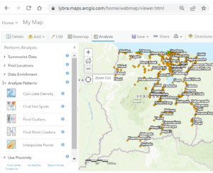
- Utilizing analysis tools for spatial querying and geoprocessing
- Creating map presentations and ArcGIS Story Maps
- Incorporating multimedia and interactive elements into web maps with ArcGIS Hub

Part 5: Sharing and Collaborating
Duration: 1.5 hours
- Sharing web maps publicly or with specific groups
- Collaborating with colleagues by sharing maps and data
- Controlling access and permissions
- Embedding web maps in websites and applications
Day 3

Part 6: Enhancing Web Maps with Apps and Templates
Duration: 2 hours
- Exploring ArcGIS Online applications and templates
- Creating and configuring web mapping applications
- Customizing the appearance and behavior of apps
- Publishing web maps as apps and sharing them with others

Part 7: Introduction to ArcGIS SiteScan Drone mapping
Duration: 1.5 hour
- Scoping a drone flight
- How to plan a drone flight in ArcGIS SiteScan
- From drone flight planning to execution
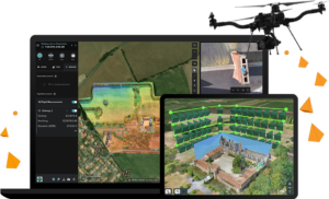
- Post-processing your drone data in ArcGIS SiteScan into Elevation models, 3D models, point clouds and orthomosaics.
- Introduction to advanced features in ArcGIS SiteScan, e.g. real-time sharing and monitoring.
Training Features
- Platform: In-Person
- Duration: 3 days, 7 modules of approx. 5 hours per day.
- Dates: TBD
- Timing: 08:30 – 15:30
- Location: Lybra Training, Coaching & Consulting, Doloresstraat #57
- Includes: Refreshments & Lunch
- Language: Dutch
- Capacity: 5-8 persons per group
Pricing: Request a quotation
Target Audience: GIS practitioners, non-GIS professionals, and anyone who needs to use the ArcGIS platform to support their daily workflows, enhance projects with geographic context, and create information that leads to better decision-making.
*Registration ends on March 27, 2023 or until we sell out!
*For individuals seeking to assess their skill level or demonstrate acquired expertise, additional evaluation or assessment mechanisms may be required. The workshop certificate should be considered as a testament to your active involvement rather than an indicator of skill proficiency.
- Have questions about this workshop, feel free to contact us with any questions or concerns?

Lybra is Esri partner in Suriname. GISsat is Esri distributor in Suriname. GISsat provides software and
core ArcGIS professional services.
Lybra provides ArcGIS training and ArcGIS Online integrations with information systems.
Q&A:
Lybra offers guidance and training towards achieving your Esri certification.
Lybra provides in-person training for groups starting at 5 persons per group.
Lybra can offer services in guiding you towards your specific GIS training needs.
Yes, Lybra offers training in drone flight planning, flight execution and post processing of dronecaptured images towards Digital Elevation Models, Digital Surface Models, 3D models, Mesh and Orthomosaics.
Yes, after successful participation and completion of training programs, participants receive a certificate.
Pricing depends on your training needs. Every request is unique. Please email us on info@lybragroup.com
with your training needs, so that we can create a fitting proposal and quotation.
Yes, Lybra is specialized in all the components of ArcGIS Online and provides basic to advanced
training in each component.
No, during the training you will be facilitated by Lybra.
Frequently Asked Questions
Lybra is Esri partner in Suriname. Lybra provides ArcGIS training and ArcGIS Online integrations with information systems.
GISsat is Esri distributor in Suriname. GISsat provides software and core ArcGIS professional services.
Lybra offers guidance and training towards achieving your Esri certification.
No, during the training you will be facilitated by Lybra.
Lybra provides in-person training for groups starting at 5 persons per group.
Pricing depends on your training needs. Every request is unique.
Please email us on info@lybragroup.com with your training needs, so that we can create a fitting proposal and quotation.
Yes, Lybra is specialized in all the components of ArcGIS Online and provides basic to advanced
training in each component.
Lybra can offer services in guiding you towards your specific GIS training needs.
Yes, after successful participation and completion of training programs, participants receive a certificate.
Yes, Lybra offers training in drone flight planning, flight execution and post processing of dronecaptured images towards Digital Elevation Models, Digital Surface Models, 3D models, Mesh and Orthomosaics.
Sheetal is a seasoned professional with a wealth of experience in delivering professional development programs to individuals, teams, and corporate organizations. Sheetal is driven by a passion for helping individuals and organizations reach their full potential, and is dedicated to delivering high-quality training programs. Lybra Training, Coaching & Consulting specializes in digital transformations for organizations in both the public and private sectors. With Sheetal leading the team, Lybra Training, Coaching & Consulting continues to deliver cutting-edge solutions for its clients in Suriname, and beyond. Sheetal will guide us through all projects Lybra has conducted in collaboration with its partners. She will be introducing various speakers who will then share their insights and provide a demo of their digital transformation results.
GISsat is the distributor of GIS solutions for Esri and Trimble. Lybra and GISsat join forces in helping their mutual clients in their digital transformations. Ramkhelawan will share the evolution of digital transformations of the past decade in Suriname. The past decade has seen a significant shift in the way the public sector approaches digital transformation. Data migration and data conversion have been crucial in modernizing legacy systems, while low-code and lean information system development have enabled faster and more cost-effective implementation of new technologies. These approaches have been instrumental in improving the delivery of services primarily for internal government processes.


