
ArcGIS Online Solutions
Enhance your maps with the powerful GeoEnrichment Service in ArcGIS Online, adding rich demographic, socioeconomic, and environmental data for deeper insights and smarter decision-making.


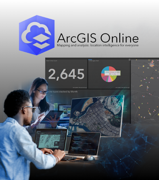
ArcGIS Online is a cloud-based SaaS platform by Esri that enables users to create, share, and analyze maps and spatial data with ease. It provides the tools to design and publish interactive maps, securely manage cloud-based data, perform advanced spatial analysis, and collaborate seamlessly. With access to Esri’s Living Atlas, users can leverage a vast library of ready-to-use geographic content for deeper insights.
Unlock the full potential of ArcGIS Online and transform the way you visualize, analyze, and collaborate on GIS projects. Let us help you harness its power to drive your business forward.
Did you know?
ArcGIS Online hosts over 25 million geographic information items from users worldwide, making it one of the largest repositories of spatial data available today. This extensive collection includes maps, layers, and datasets that can be leveraged across industries for analysis, planning, and decision-making.
Our Services
ArcGIS Online Integrations
Unlock the full potential of ArcGIS by seamlessly integrating it with our low-code platform. Streamline operations, enhance efficiency, and drive business growth with tailored solutions designed to fit your needs.
ArcGIS Online Training
Empower your team with our comprehensive ArcGIS Online training programs. Gain hands-on expertise in mapping, spatial analysis, and data management to maximize productivity and operational efficiency.
ArcGIS Online Licenses & Credits
Ensure uninterrupted access to ArcGIS Online’s powerful capabilities with the right licenses and credits. Keep your projects running smoothly and leverage GIS technology to drive informed decision-making.
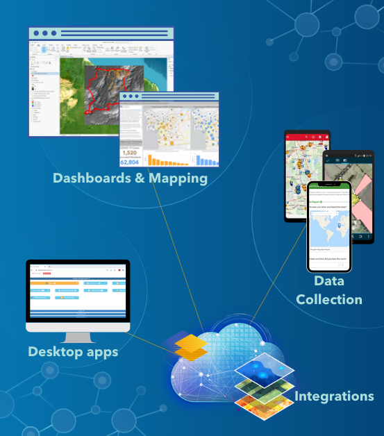
ArcGIS Online Integrations
Seamlessly integrate ArcGIS Online with your existing information systems and data sources using APIs and connectors. Ensure your geospatial data fits effortlessly into your workflows, while secure cloud hosting keeps your maps and data up-to-date and accessible anytime, anywhere.
ArcGIS Online provides a comprehensive suite of tools and services designed to revolutionize how you work with spatial data.
What You Can Expect:
Interactive Web Maps and Apps: Easily create, share, and interact with dynamic maps and applications accessible from any device. Enhance data visualization and engagement with real-time geographic insights.
Advanced Spatial Analysis: Perform sophisticated spatial analyses to uncover trends and relationships, including layer overlays, density calculations, and hotspot detection.
Secure Data Management: Store, manage, and share your geospatial data securely in the cloud, ensuring data integrity and accessibility.
Scalability and High Performance: Leverage a scalable platform designed to handle large datasets and high-demand applications without compromising speed or efficiency.
Customizable Solutions: Tailor ArcGIS Online to meet your organization’s needs with custom apps, dashboards, and industry-specific templates for maximum flexibility.
ArcGIS Online Training
Master the essentials of ArcGIS Online—from creating, sharing, and analyzing web maps to performing advanced spatial analyses and securely managing data in the cloud. Our hands-on training incorporates real-world applications and personalized support, ensuring seamless integration into your workflows and enhancing your geospatial capabilities.
Leveraging ArcGIS Online: From Data to Dynamic Web Maps
Join us for a comprehensive three-day workshop designed to help you transform raw geospatial data into interactive, dynamic web maps.
Who Should Attend?
This course is ideal for GIS professionals, analysts, and enthusiasts looking to enhance their web mapping skills. No prior experience with ArcGIS Online is required—beginners are welcome!
What You’ll Learn:
- Creating & Publishing Web Maps – Design interactive maps for seamless data visualization.
- Spatial Analysis Techniques – Perform location-based analytics to uncover insights.
- Cloud-Based Data Management – Securely store, organize, and share geospatial data.
- Optimized Workflows – Learn how to reduce errors, enhance information flow, and improve client satisfaction through tailor-made geospatial solutions.
Empower yourself with industry-leading GIS skills and unlock the full potential of ArcGIS Online.
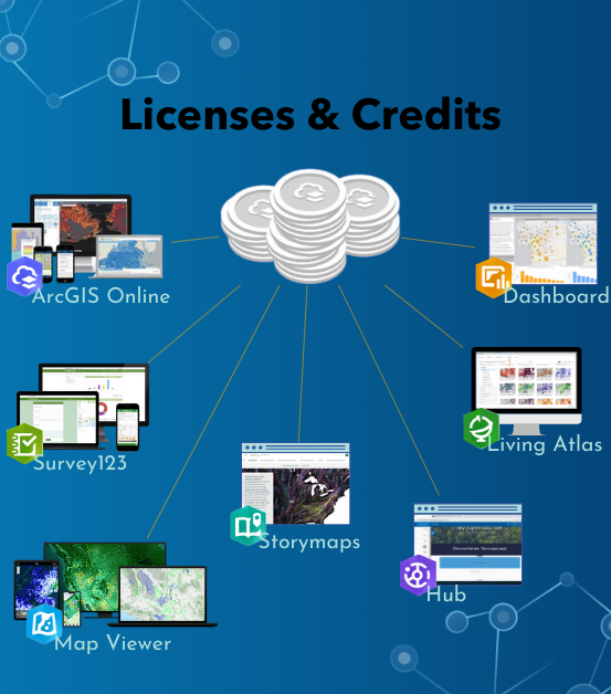
ArcGIS Online Licenses
Enhance collaboration and maximize efficiency by assigning the right ArcGIS Online license to each team member based on their role and responsibilities.
Available licenses:

ArcGIS Online Creator license
Users can create and share interactive web maps and applications, perform spatial analyses, and manage members, groups, and content for collaboration. This license is ideal for GIS Analysts, Cartographers, Data Scientists, and Project Managers who need comprehensive tools for creating and analyzing geospatial data.

ArcGIS Online Viewer license
Allows users to securely view maps, applications, and dashboards, participate in private groups to access spatial information, and monitor real-time data and key performance indicators (KPIs). This license is suited for Executives, Decision Makers, Stakeholders, and Field Supervisors who require access to spatial information without the need to create or edit data.

ArcGIS Online Mobile Workers license
Provides tools for data collection, surveys, and inspections directly in the field. Users can open work assignments with relevant field information, navigate in-app, and share their location for operational efficiency. This license includes all capabilities of the Contributor user type and is perfect for Field Technicians, Surveyors, Inspectors, and Field Operations Managers who need to perform their tasks on the go.
With the right license, users gain access to powerful GIS tools for creating, analyzing, and managing spatial data while ensuring secure and seamless collaboration across teams.
Available licenses:
ArcGIS Online Creator license
Best for: GIS Analysts, Cartographers, Data Scientists, Project Managers
- Create and share interactive web maps and applications
- Perform spatial analyses for data-driven decision-making
- Manage members, groups, and content for collaboration
Ideal for professionals who need comprehensive tools to develop, analyze, and manage geospatial data.
ArcGIS Online Viewer license
Best for: Executives, Decision Makers, Stakeholders, Field Supervisors
- Securely view maps, applications, and dashboards
- Access private groups for critical spatial insights
- Monitor real-time data and key performance indicators (KPIs)
Perfect for users who need access to GIS insights but do not require editing or data creation capabilities.
ArcGIS Online Mobile Workers license
Best for: Field Technicians, Surveyors, Inspectors, Field Operations Managers
- Collect data, conduct surveys, and perform inspections in the field
- Access work assignments and navigation tools within the app
- Share locations and collaborate in real-time for operational efficiency
This license includes all Contributor-level capabilities, making it ideal for field teams that require on-the-go GIS access.
Find the right license for your team and unlock the full potential of ArcGIS Online. Let us help you get started!
ArcGIS Online Credits

Power your GIS workflows with ArcGIS Online Credits—the key to unlocking premium features and advanced capabilities.
Credits serve as the currency for accessing essential ArcGIS Online services, including:
- Advanced Spatial Analysis – Perform in-depth data modeling, proximity analysis, and geoprocessing.
- Cloud Data Storage & Hosting – Securely store, manage, and share your geospatial data.
- GeoEnrichment Services – Enhance maps with demographic, socioeconomic, and environmental data.
Ensure seamless operations by securing your credits today—keeping your projects running smoothly and maximizing the full potential of ArcGIS Online.
Contact us!
Contact us today to learn more about how our services can help your organization thrive in the digital age.
Click the button below to provide your details, and we will reach out to schedule a meeting.